It’s been a comparably mild hurricane season for the Atlantic and the U.S. East Coast, but those areas are not out of the woods yet. Two storms this week could have an impact on travel for those scheduled to fly or cruise in the Caribbean and along the U.S. East Coast.
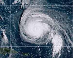
The first is Tropical Storm Jerry, which is likely to impact travel to the Leeward Islands, British Virgin Islands, and U.S. Virgin Islands through Friday. As of 5 a.m. EST on Thursday, Jerry was about 400 miles east-southeast of the northernmost Leeward Islands, moving west-northwest at 20 mph, with winds of 65 mph. Gradual strengthening is forecast, and Jerry could become a hurricane by late Friday or Saturday.
The National Hurricane Center (NHC) expects Jerry to turn even more northwest later on Thursday and then move north on Friday, and Saturday, passing near the northern Leeward Islands on Thursday night.
For now, the NHC has a Tropical Storm Watch in effect for Antigua and Barbuda, Anguilla, St. Kitts, Nevis, St. Barts, St. Martin, and Sint Maarten. It’s also alerting “interested elsewhere” in the northern Leeward Islands to be vigilant.
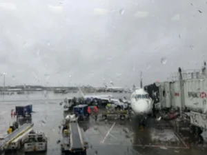
The second, and probably more consequential storm for the travel industry, is a nor’easter expected to develop off the East Coast this weekend, bringing with it heavy rain and possible flooding all along the U.S. East Coast.
Forecasters expect cooler weather in the Northeast before conditions make it likely that a nor’easter forms off the East Coast this weekend. AccuWeather says that the rain is likely to start in the Carolinas, eastern Virginia, and southeastern Maryland on Saturday. By Sunday morning, the stormy area could extend all the way through the eastern Mid-Atlantic and then to southern New England by Sunday night. The Outer Banks of North Carolina are especially vulnerable after last week’s severe erosion.
The storm could last into early next week before weakening and moving farther offshore by Tuesday. AccuWeather is warning that the storm could produce “major flooding, beach erosion, and power outages” along the coast.